
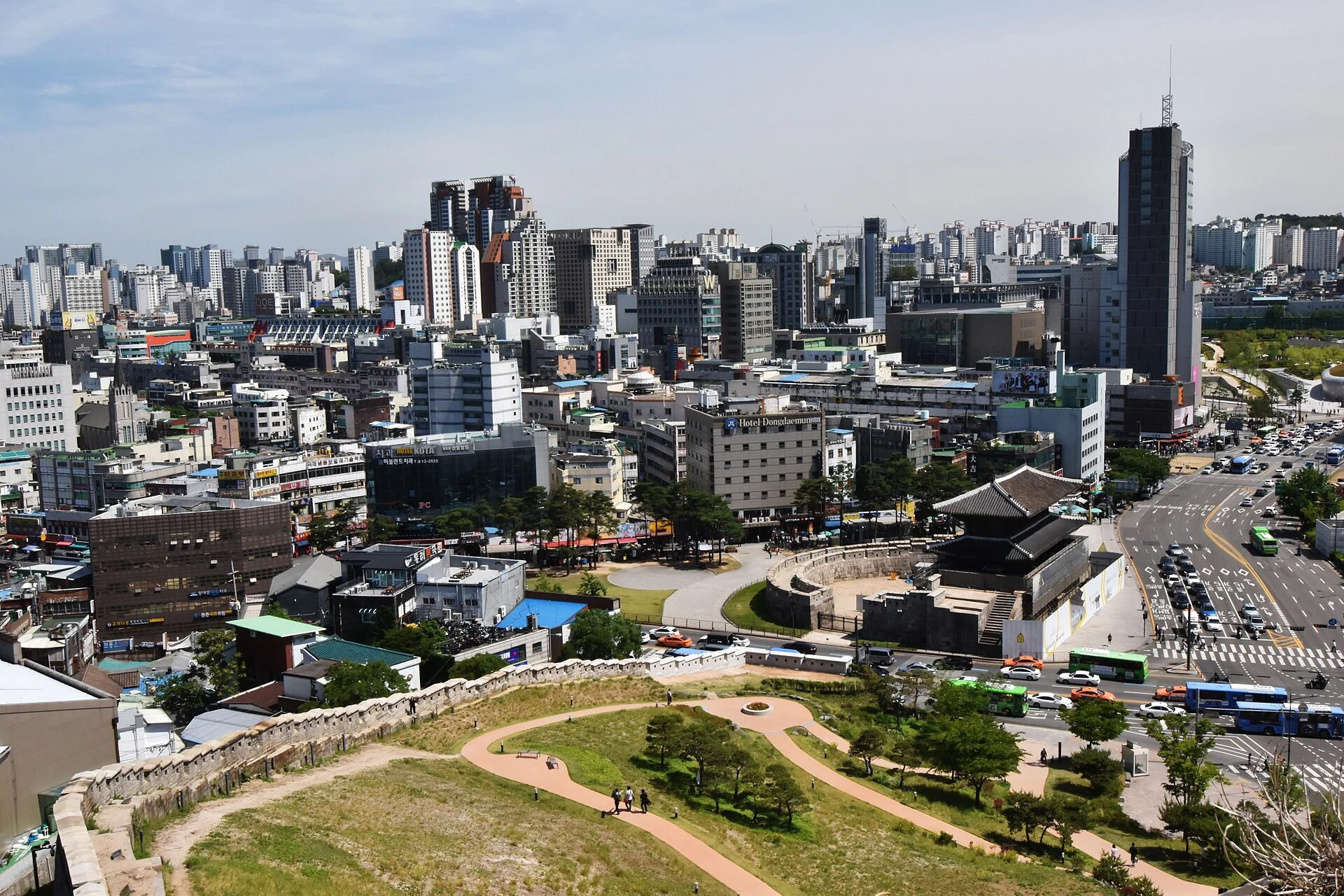
Naksan is a city-wall walk with a hill in the middle, not a flat pavement between two subway stations. Its pleasure comes from seeing the wall change with the terrain and from understanding how a boundary runs through today’s neighborhoods. A good plan begins by choosing whether you want the whole section, a shorter park visit or an introduction at the City Wall Museum.
The direction matters because it determines the first climb, your meal area and the station at which you finish. “Go to Naksan” leaves all three unresolved. Save an actual gate or park entrance and decide where the walk will end before following the wall uphill.
What the official section includes
The Seoul City Wall operator’s Naksan route runs Hyehwamun Gate to Heunginjimun Gate. It currently lists 3.2 kilometers and about one hour. That is the operator’s route estimate, not a time measured for your group and not an allowance for long photo stops, the museum or dinner. Older tourism material can use a different distance, so retain the actual route and map rather than combining figures from different descriptions.
The operator describes Naksan as 124 meters high and relatively gentle compared with the city’s other inner mountains. “Relatively gentle” does not mean level, continuously step-free or suitable for every visitor. There are slopes and stair approaches, and you must still descend after reaching the viewpoint.
| Version | Start and finish | Choose it when | What it leaves out |
|---|---|---|---|
| Full north-to-south section | Hyehwamun, Naksan, Heunginjimun | You want the wall’s changing terrain and a Dongdaemun ending | A long museum visit unless you add time |
| Park and return | Hyehwa approach, Naksan Park, return to Hyehwa | You want one viewpoint and dinner around Daehakro | The complete gate-to-gate wall section |
| Museum and lower wall | Dongdaemun/Heunginjimun Park area, museum, limited outdoor section | Interpretation matters more than completing the climb | The summit unless you deliberately extend |
For the complete walk, begin at Hyehwamun
The route page identifies Hansung University Station Exit 4 on Line 4 for the Hyehwamun approach. The city’s more recent Naksanseonggwak-gil guide places the wall sequence through the path behind the Catholic University of Korea, Jangsu Village and the Naksan Park area before descending toward Heunginjimun.
Find Hyehwamun and the signed wall approach before beginning the climb. Keep the operator’s map available at junctions. A residential side street can be near the wall without being the intended public route, and a stairway toward a private doorway is not a shortcut.
As you gain height, stop at a place wide enough to let others pass. Look back at how the built neighborhood sits below or beside the defensive line. This makes the walk more than a series of skyline photographs: the wall follows a topographical logic that becomes visible as you move along it.
Continue through the permitted Naksan Park path and descend toward Heunginjimun Park and the gate. Keep that gate as the actual finish. Adding the next city-wall section simply because the route continues creates a different outing with another distance and return decision.
A shorter Hyehwa outing is a different route
For a park-led visit, the official route page gives Hyehwa Station Exit 2 as a Naksan Park approach. This reaches the hill from a different starting point from Hansung University and Hyehwamun. Choose it for a park/viewpoint visit that returns to the Daehakro side, rather than claiming you have walked the complete gate-to-gate section.
Use Naksan Park’s central public area as your orientation point, choose one permitted outlook and decide on the return before wandering into another section. A there-and-back route has a simple advantage: you can shorten it when the group has had enough without discovering that your bags or dinner reservation are at the other end.
The return is part of the effort. A hill that feels manageable on the way up may be uncomfortable to descend in darkness, on wet steps or with tired knees. When choosing between a sunset photograph and an earlier return, consider the footing and lighting on the actual route you will use, not only the view from the top.
Read the wall through its stones
The operator specifically draws attention to changes in stone shape along the path behind the Catholic University. Use those changes as a reason to slow down. Compare the size and regularity of blocks and the way the wall meets the slope, then read any nearby interpretation before assigning a construction period.
A restored section and an earlier surviving section can look coherent from a distance. Look for what the signs actually establish. Avoid concluding that a neat surface is modern or an irregular stone automatically belongs to the earliest phase; appearance alone does not settle the chronology.
Choose one stretch to inspect closely and one wider view that shows how the wall relates to the city. Together they make a more informative record than several photographs of the same skyline. Keep off the wall itself and remain on the designated path.
The City Wall Museum can be the main visit
The Seoul City Wall Museum branch page gives 283 Yulgok-ro, floors 1–3 of the Seoul Design Support Center. It lists free admission,09:00–18:00 and Monday/January 1 closures. Its ordinary approaches include Dongdaemun Station on Lines 1 and 4. The museum and park are separate access decisions; a wall path available outdoors does not keep a museum open.
Use the museum to understand construction, damage and restoration before taking a limited look at the lower wall. This version suits someone interested in the historic boundary who does not want the full hill. Confirm the accessible building entrance and facilities independently rather than treating the word “museum” as a complete mobility assessment.
If you intend to end a full walk at the museum, protect its last useful visiting time. A long outdoor session that reaches the building near closing can remove the interpretation you wanted. Seeing the museum first is a reasonable reversal when its contents matter more than the direction of the walk.
Daylight, residents and the route home
The operator lists the Naksan trail as open 24 hours. That does not establish continuous lighting, an open toilet at every point or a recommendation to begin a first visit late at night. For an unfamiliar route, daytime gives more room to read junctions and assess the descent.
Residential lanes sit beside parts of the walk. Keep voices low, avoid filming into homes, and leave doors and steps clear. Use public paths even if a social-media photograph suggests a better view from someone’s threshold.
At the finish, choose the station that serves your accommodation and make dinner an explicit next stop. The night-view comparison helps decide whether Naksan’s slopes fit your evening at all; the subway guide explains why the correct entrance, direction and final connection still matter after the walk ends.